Viewing entries tagged
surfing

"The Devil's Road" Main Expedition, Day 34

April 3rd (Punta Conjeo)

Back on the highway and heading south, our next stop was the town of San Hilaro, only a few miles off the highway. Nelson and Goldman described it as a small village within an arroyo with a small stream of good water flowing. A few palm trees lined the banks and they stayed for several days to water their horses and gather a few specimens.

Now, there is only a single ranch at San Hilaro. The water still flows, but I would not say was "good." There are a few palms growing in clumps, but mostly the area along the arroyo is a tangled mess of mesquite and acacia. The stock runs free and the ranch was not very inviting so we turned around and headed back to the highway.

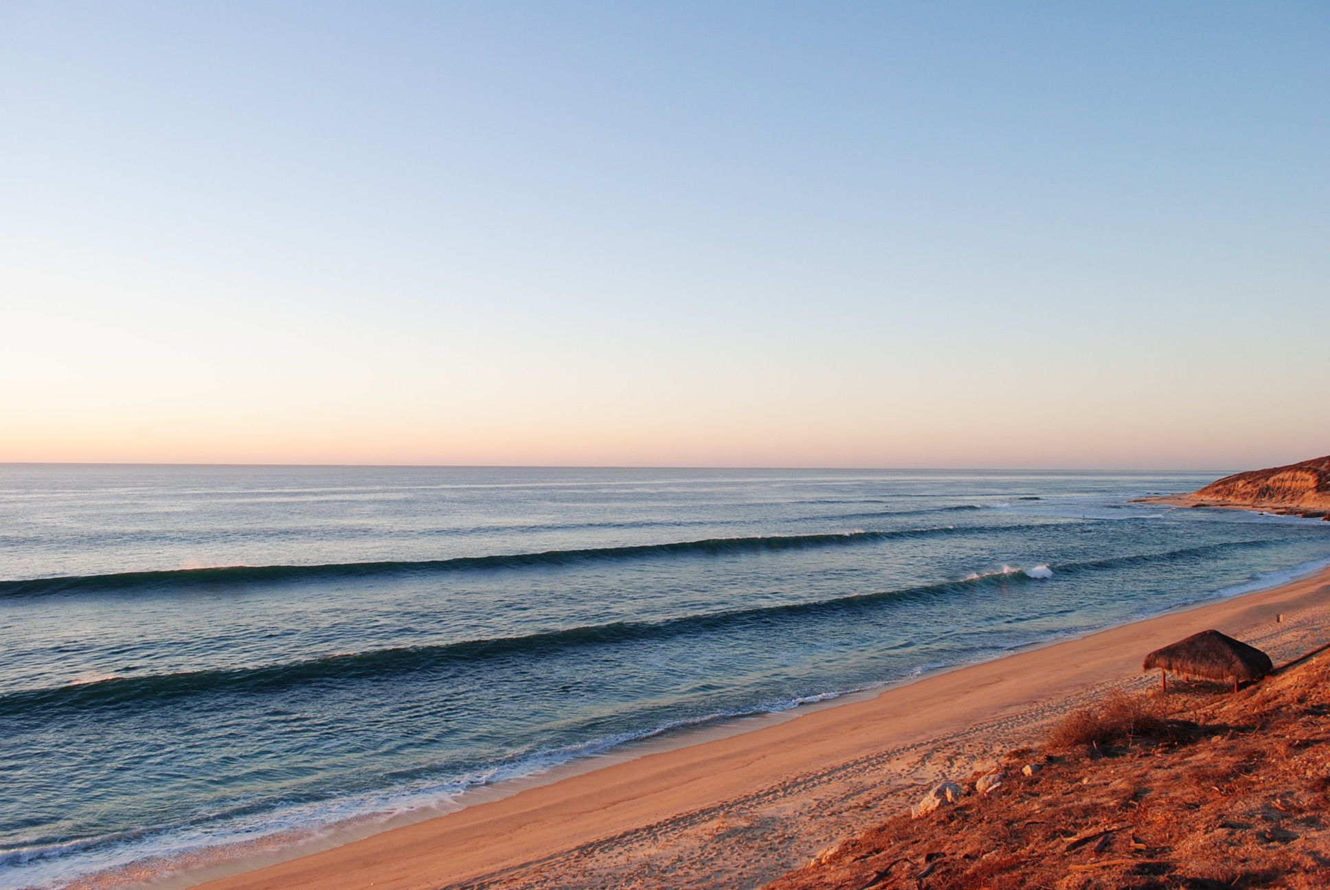
Ten miles of dirt road stood between the pavement and the sandy beaches of El Conejo. We thought it would be nice to camp on the beach, dip our toes in the water, and see a part of the Pacific side we had never been to. If you surf, this is the place to be. It is a perfect left point break without crowds. There were four vans parked on the bluff overlooking the waves, all huddled to protect their camp at the center from the wind. They had stacked rocks, laid out surfboards, and strategically placed driftwood to keep the 20-knot winds from blowing sand into everything they owned.

These four groups (three couples and one single guy) were all traveling separately but found themselves in a similar location with a similar mindset: surfing. One couple was just starting a two-year journey to South America. Another was from the Pacific Northwest and was escaping the snow and bad weather, while the last couple didn't have any plans and was not sure where they were going next.

It is not a bad place to be or a life to live when you can walk down the beach to the fishermen and buy lobster for dinner, "showers" are available at the ranch nearby for 50 pesos per person where there is a water tank elevated and a PVC pipe that dumps cold water. This is private property and a guy comes around every morning to collect your name, logging it into an account book.

"The Devil's Road" Main Expedition, Day 46

Guest blog by Associate Producer Bri Bruce

Woke to a thick haze in the air, a mixture of fog and smoke—likely burning trash.

JT, Papa and I headed to Cerritos early, where I rented a board from a guy named Juan at one of the stands we had seen the day before. The surf was decent, though somewhat disorganized, more or less an extended beach break that sweeps around a rocky point below a large hotel on the cliff. There were only a few others out, and I enjoyed a handful of fast waves with short rides. 

I did a short interview with JT afterwards, then interviewed Juan who told us all about the changes he’d seen at this beach in the last ten years. The beach used to be relatively unknown, and was unbuilt, “undiscovered.” But now, more than a few large hotels dot the stretch of beach, and people come from all over the world to surf and swim. Juan explained how sad it was, but ultimately it was good for business. He and his brother owned the stand, provided rentals and lessons to beachgoers, and slept right there in the sand most nights.

We spent a few hours in the evening in the central part of Cabo San Lucas, walking the stretch of beach in front of the resorts that gave us a good view of Land’s End, the boats leaving and entering the harbor, and all the people.

We found an out-of-the-way place for some tacos and beer, then roamed around the main streets to film some of the nightlife. Loud music poured from the open entryways of bars and nightclubs. Men stood on the sidewalk handing out flyers, attempting to usher us into their establishments. There were families, and sunburnt couples, gaggles of women in high heels, groups of men yelling and jostling one another. Every so often we’d pass a bachelorette party, colorful tiaras or boas setting them apart.

Once we had our fill of Cabo, we made our way back to Todos Santos. We were silent on the drive home, most of us likely reflecting on the day, and the week, knowing some of us would be leaving in the morning.


"The Devil's Road" Main Expedition, Day 45

Guest blog by Associate Producer Bri Bruce

Awake before the others, Papa and I decided to go for a drive to see the area. We headed north toward La Pastora, through a sparsely built area, then drove out to a beach where several cars (including a school bus that had been converted to an RV) were parked in the sand. There were several surfers in the water beyond the rocky beach and we stood watching them for a while, noting they were wearing wetsuits in the much cooler water. We returned south, heading for Pescadero, and wound through the hills and dirt roads there, stopping at another beach, this time deserted. ATV tracks scarred the beach, not a person in sight. The beach was not conducive to swimming—or surfing—as the step beach caused the waves to double over and break right on the shore.

Continuing south again, we came to Cerritos, taking a dirt road from Mex19 to the ocean. Between the two large hotels on the stretch of beach, we found a smaller road that dead-ended into a series of tents and umbrellas. There were vendors selling hats and jewelry, tourists lounging about in beach chairs. Several stands of surfboards were propped up, with signs reading “Rentals” and “Lessons.” After doing a quick scan of the boards, and talking to a few of the people offering rentals, I found a stand to come back to tomorrow.

After a late breakfast back at the complex, JT and Papa left to film on the bikes, so Heidi, Jade, and I walked around Todos Santos’s historic district to visit a few museums and galleries. We stopped for some fresh fruit with chili and lime at the mission before heading back to plan the rest of the trip’s filming. 

"The Devil's Road" Main Expedition, Day 43

Guest blog by Associate Producer Bri Bruce

Went into town to try to meet Rigoberto at his tequila shop for an interview only to find he had gone to Jalisco for the week. Instead, we bought food for the next few days and wandered about town. 

After returning, I drove south alone along the dirt road to a large hotel down the beach to rent a surfboard. Being a longboarder, I rented  the only longboard they had, a blue and yellow eight-footer that had seen better days. Knowing that the wind was blowing offshore, and the tide was dropping, I rushed back to the condo and paddled out to the point just before sundown. I spent the golden hour riding chest high waves, one after the other, all by myself. 

Once the sun set behind the peninsula, I put my board on the beach and went bodysurfing with JT until dark. Papa came out to watch us, laughing as we acted like children rolling around in the surf, letting the waves push us up the slope of sand, and then the undertow take us back out.

Later, all of us watched the moon rise over the gulf, a big golden orb pushing through the mirage-like layer of heat over the ocean. For some time we stood watching the sky grow darker and the stars come into view. We pointed out all the constellations we knew, and the stars that comprised them: Sirius, Rigel, Betelgeuse the brightest.

We ended the day by cooking a meal together and sharing stories of the journey thus far. 

Looking south toward the point.

Looking south toward the point.

The carapace of a sea turtle carcass washed ashore. 

The carapace of a sea turtle carcass washed ashore. 

"The Devil's Road" Main Expedition, Day 41

Guest Blog by Associate Producer Bri Bruce

We woke early an spent the day on horseback. Oscar took us from the villa stables to La Boca de la Sierra, winding on a dusty road through the foothills of the Sierra la Laguna. Along the way, he stopped to point out and several species of plants and flowers, explaining what native Baja Californians would use for medicinal purposes. 

At one point, we traversed the Arroyo San Bernardo, and for a moment I felt as I imagined Nelson and Goldman once did during their time here, looking to either side of the road at the expanse of the dry river basin. To think that in this very canyon they rode their own horses during their own trek, over a century before. Suddenly we heard a loud whooshing noise, cross between a strong gust of wind and a plane flying overhead. When we looked up to where the sound was coming from, whatever it was was moving--and quickly--we saw a person, clad in helmet, gloves, and ropes, suspended from and rolling along a cable high above the arroyo. Zipline. All this before I could presume that little had changed in the last hundred or so years, with the exception of trash hung up in the underbrush and the branded cattle roaming about. Shortly after we came upon a small outpost, vans emblazoned with "Cabo Adventures," offering ziplining and ATVing to tourists from the cape. 

We continued on, noting the number of ziplines in the area, the platforms of various heights that were scattered among the peaks. Every now and then we heard someone whooping as they swung from one platform to the next along one of the the cables. We couldn't go five minutes without a bus full of smiling tourists lumbering down the narrow road or convoy of ATVers at our heels, revving their engines in an attempt to urge us to guide the horses to the shoulder. We were left to choke on their dust and calm the horses for some time afterward.

The road ended in a picturesque, rocky canyon that had collected rainwater in blue pools in its basin--a welcome reward for the journey. The water was remarkably clear for having been stagnant for some time, shrouded in grasses, a lone palm at the southeastern end. The horses drank and trotted through the water, clearly pleased, as several of them began pawing at the water, letting it splash around us. We did our best to cool off before filming a black water snake we had happened upon near a marshy crevice at the water's edge. Oscar tended to the horses, checking their saddles and upturning his hat, filling it with water from the canyon, and offering it to them to drink, pouring the rest over their necks and flanks.

I have a new respect for Nelson and Goldman and all they endured and were able to accomplish in this place. They must have been incredibly seasoned horsemen because I cannot imagine riding over 2,000 miles on horseback when only a day's ride has left me so sore and bruised I can hardly sit. 

On our return, the horses were eager to get back, picking up their pace to a trot despite Oscar's insistence (and our pulling at the reigns) that we not let them. Undoubtedly they were also growing more agitated at the constant convoys of ATVs whizzing past, coating us all in a fine layer of Baja dust. 

We finally made it back to Rigoberto's villa, hot and thirsty, the horses sweating and snorting. We helped Oscar wash and brush the horses, and then tie them up beneath some trees near the aviary to feed them alfalfa. Afterward, Oscar helped us in recreating a photograph that Nelson and Goldman took on their expedition of a vaquero in traditional dress. We were in awe. The photos we captured were nearly identical, down to the way the horse held his ears, the brim of Oscar's hat, the handmade leather chaps and saddle. This was truly a highlight of our time in the area, and truly a recreation of the original expedition we're aiming to recreate.

Oscar tending to his horses.

Oscar tending to his horses.


Later in the afternoon, once packed, we bid Rigoberto and Oscar farewell and thanks, and continued south around the cape. After ten or so miles on a rutted and windy dirt road toward Cabo Pulmo, we arrived at our next destination: a gated community of houses and condos atop a cliff overlooking the ocean. We're staying at a condo belonging to a surfer from Southern California in one of the last small housing developments along the road.

The entire drive, as the sun was slowly descending toward the western horizon (and not over the ocean as I'm so accustomed to seeing back home) I watched the surf. The blue-green waves rolling around the rocky points near Nine Palms and Shipwrecks brought butterflies to my stomach.

We watched the sun set and the moon rise from the beach below the condo, watching as JT and Jade went for a swim, struggling with the shorebreak and the undertow. 

"The Devil's Road" Main Expedition, Day 30

Scorpion Bay to Comondu

San Juanico is the official name for this surfing and fishing village. The locals’ lives are spent around fishing and the gringos all are there for the surfing. During our visit, overlooking the bluff at the best surf spot around, known as Scorpion Bay, there were only three surfers in the water. Back home in Santa Cruz to have clean, head high waves that one could ride for half a mile with only two other surfers would be absolute paradise. I can see the attraction to this place.

Bikes on bluff overlooking Scorpion Bay (San Juanico)

Bikes on bluff overlooking Scorpion Bay (San Juanico)

"The Comondus" is how most gringos will refer to the two towns of San Jose de Comondu and San Miguel de Comondu. Both lie about a mile apart and are settled in a beautiful canyon with high lava and basalt rock walls. Goldman wrote that while standing on the wall edge overlooking the valley of these two towns is "one of the most beautiful in all of Lower California." Date and fan palms are widely abundant, crops of various vegetables are grown, and orchards of many varieties of trees seem to be happily growing in this well watered and fertile place.

Inside Mision San Jose de Comondu

Inside Mision San Jose de Comondu

It is a very sleepy and slow paced town with not much going on. When we arrived at the mission site, there was a group of children on a field trip. That seemed to be the most excitement the town had seen in a while. Nelson and Goldman wrote very little about this beautiful oasis town even though they spent five days here. In 1905, Nelson writes that date palms were scattered irregularly along the stream in a thin line through the vineyards and fields. Today the entire bottom of the canyon is a thick forest of date and fan palms. Several years ago the forest was subjected to a fire of strong intensity. The scorch marks reached to the tops of most trees and left a healthy fire scar on each tree. I suspect that it was a controlled burn to remove debris and litter dropped from the trees and to burn the dead hanging leaves of the fan palms.

While waiting for our next move and giving ourselves a break from filming in the harsh light of midday, we met and talked with two dirt bikers that rode into town. Greg and Eric had split off from the same group that we met in La Purisima. Both these guys were from Washington State and were quite the characters. We swapped motorcycle stories, learned about each other and our families, and mostly talked about how beautiful Baja is.

While we were all sitting on the side of the cobblestone road in the shade of a young ficus tree, another gringo approaches us from around the corner holding a map. He seemed glad to find someone that spoke English. Then he was glad that someone could tell him where he was. After that, his disappointment began to show. He was carying a single page map of Mexico that had a VERY small sliver showing Baja. He was using that to navigate from Cabo to San Diego.

I pulled out our map and showed him that he was 2 1/2 hours from where he needed to be (which was back were he had come from) and that no other road north was a viable option considering his vehicle and choice of navigation methods. This poor guy from Pennsylvania saw no humor in the matter and walked away with a curt "Thanks."

We camped that night a few miles out of town, well enough away from the water and the bugs, and just off the road so as not to be bothered by the noise of the traffic. Four cars drove past us that night. All of them slowed a bit (most likely they could see the flames of our fire) and then slowly drove off. One even gave us a little honk, just to say hi!